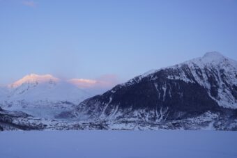
Alaska’s Christmas storm of 2021 has caused chaos in Interior Alaska, as well as some climatological phenomena of interest across the state.
National Weather Service climate researcher Brian Brettschneider is back for Alaska Public Media’s “Ask a Climatologist” segment, and he says some places, like Cold Bay, saw temperatures spike into the 60s. While in Fairbanks, between all the snow and rain on Sunday, the total precipitation for the day amounted to 1.93 inches, which is the community’s third-highest daily total ever.
Brettschneider says for that to have happened in December is astounding.
Listen:
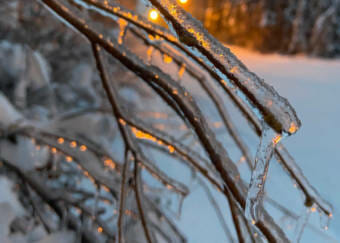
Brian Brettschneider: Yeah, that’s just a really staggering amount of precipitation. Because in the winter our atmosphere just can’t hold as much moisture. And so our winter totals are always less than they would be in the summer. So to have this third largest on record to occur in a winter month is really unprecedented in a cold climate location like Fairbanks. Of course, anything that you can imagine as far as a negative impact is occurring. So when you get ice on the roads, it’s just not going to go away in many cases until like March. There’s been cases in recent years where ice that accumulated in November caused accidents, even fatal accidents, in March. So that’s going to be a persistent hazard. And we’re going to have this re-freezing because it’s going to get pretty cold in the next week or so and there’s all this slush. So it’s just going to be a mess. There’s just no other way to describe it.
Casey Grove: What about elsewhere in the state, what happened with this big storm that came through?
Brian Brettschneider: Well the storm and, again, we talked about the precipitation that accompanied the storm, but we’re also talking about the temperatures. In Cold Bay, the temperature spiked to 62 degrees on Sunday, around mid-morning. And that broke the daily record by 18 degrees, and it broke the December monthly record by 8 degrees. You know, to break a monthly record is crazy enough. Usually, when you break a monthly record, it’s by a degree, sometimes by 2 degrees. But to break it by 8 degrees is just historic. And then over toward Kodiak, the Kodiak Airport recorded 65 degrees at 3 p.m. Sunday. Again, this is a temperature that’s also supported by the weather balloon that was launched at the same time. But 65 degrees, just like Cold Bay, is a daily record and it’s also a monthly record for Kodiak, and it breaks their monthly record by 9 degrees — just an unheard of amount to break a monthly record by. And then to go even one step further: At the tide gauge, just southwest of the airport, they recorded a temperature of 67 degrees. And that establishes a new statewide high temperature record for any day in December — any year, any part of the state, that’s the highest temperature ever recorded in Alaska in the month of December.
Casey Grove: Those are just balmy, ridiculous temperatures for December.
Brian Brettschneider: Yeah. And, now on the other side, and this is very common in what we call a highly amplified situation where you’ve got a major warm-up on one side of the storm system, but you have cold on the other side of the system. Well, over in Ketchikan, they’re setting record lows. In fact, they set a record low temperature of zero degrees on Christmas. That was the first time in the month of December that they’ve hit zero degrees since 1977. And then, Sunday, with a cold record high of only 18 degrees. Their high temperature in Ketchikan was 23 degrees lower than it was in Fairbanks. And I’ll have to dig through the numbers, but I’m sure that that has not happened very many times. And Ketchikan is actually on track to have their coldest December since 1933. And they’re second coldest overall. So this is a really highly amplified pattern that’s warm on one side and cold on the other.
Casey Grove: Is there a way to kind of measure over the course of a season the wackiness, for lack of a better term, or the roller coaster ride of high temps and low temps?
Brian Brettschneider: Yeah, so for each day of the year, you can not only say, “OK, it was 10 degrees above normal or 5 degrees below normal.” But you can characterize that in terms of standard deviations. The problem with that is that temperature distributions are not nice and normally distributed. It’s not a bell curve, like many people are familiar with, they tend to skew one way or the other. So it’s a little bit problematic. But there are some ways to characterize the variability. It does feel like there’s been more of that this year. And we could also perhaps talk about how quickly it bounces between cold patterns and warm patterns. And so for November, we had a lot of very, very cold days, a lot of very large temperature anomalies, but they were cold after cold, after cold, after cold. This month, we’ve had several huge swings between warm and cold. And so there has been, you’re right, a lot of back and forth this December and it does feel like it’s more than typical.
CG: Last question: Brian, why did this have to happen basically on Christmas or the day after and screw up so many people’s travel plans?
Brian Brettschneider: Well, this may be the year, we talked about the great Christmas storm, I think it will go down as the most noteworthy Christmas weather in the Alaska climate record for Christmas day for sure.
Casey Grove: But why Brian? Why?
Brian Brettschneider: I guess somebody was on the naughty list this year. We’ll just have to figure out who it was.