
Listen to this story:
Juneau had a relatively uneventful glacial outburst flood this summer, just one year after the city’s largest flood on record. On Friday, scientists at the University of Alaska Southeast presented their latest data and ideas about how this climate change-driven threat could evolve.
Eran Hood, an environmental scientist at UAS, told a crowd at Egan Library that the source of the flood has shrunk. But that doesn’t necessarily mean Juneau’s already seen its largest flood.
“We’re really eager to know, like, well, what’s going to happen in the future with this,” he said. “We’re, what, a decade and a half into it? We’ve got a ways to go.”
Juneau’s glacial outburst flood has become an annual emergency for suburban Mendenhall Valley neighborhoods. In 2024, the freezing torrent flooded around 300 homes. The City & Borough of Juneau and the U.S. Army Corps of Engineers built a temporary flood wall before the record-breaking flood in 2025, which has curbed the disaster.
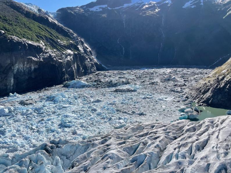
Suicide Basin is the source of the flood.
“It is about three-quarters of a mile long and about a third of a mile wide,” Hood said. “So it’s a very large area, and it can hold back a tremendous amount of water.”
Steep rock faces make up all but one of the basin’s walls. The last wall is an ice dam formed by Mendenhall Glacier. Each year, pressure builds against the ice until water bursts out under the glacier and drains into the valley below.
Scientists say three things control how much water Suicide Basin can hold.
First, icebergs. As Suicide Glacier retreated, it carved out Suicide Basin and left massive chunks of ice behind. When Hood and his colleagues discovered the basin caused the glacial outburst flood in 2011, it was so filled with ice that they walked across it.
Now they’d fall into freezing water if they tried because most of the icebergs have melted.
Jason Amundson is a glaciologist at UAS who studies the flood with Hood. At the presentation, he said ice displaces water.
“Previously, that was a big driver of the changes — that the basin was filled with ice, and then as that ice was wasting away, we were gaining a lot of storage,” Amundson said. “We’re not going to gain much more storage from that.”
Second, the entire Mendenhall Glacier is melting due to human-caused climate change. That means it’s getting thinner, so the ice dam is shorter than it was in 2018, when Amundson, Hood and their colleagues started creating 3D maps of the basin using drones.
Hood said that means it should hold less and less water.
“Eventually, as the ice dam gets lower and lower, the volume of the floods have to decrease over time,” Hood said.
Over the past 25 years, Mendenhall Glacier has been thinning between 8 and 10 feet per year in the area near Suicide Basin, according to data presented at the talk. Amundson said he expects that trend to continue.
Third, the basin is expanding into the side of Mendenhall Glacier since the ice dam is dynamic. That could add more storage capacity.
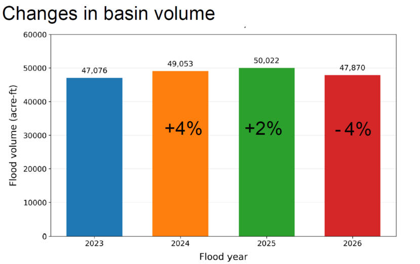
Taken altogether, Hood said Suicide Basin’s water storage increased by 4% between 2023 and 2024, then increased again by 2% in 2025.
But this year, he said it dropped.
“This is the good news right here: it actually decreased by 4% this year,” Hood said. “That’s not to imply that we’ve turned the corner and it’s only going to go down from here.”
He said the basin’s volume is not the only thing that controls the flood’s peak. He said rainfall and the rate the torrent flows down from the glacier are important factors when looking at possible impacts.
“The volume isn’t changing much, but the peak can change pretty substantially,” Hood said.
That’s where the glacier’s natural plumbing comes into play. Amundson said there’s a drainage system hidden beneath the ice, and it moves water more quickly when more water is flowing through it.
“In 2025, the flood occurred during an atmospheric river, and even before that, the discharge down the Mendenhall River was elevated compared to this year,” Amundson said.
He said all that water lubricated the drainage system in 2025, so when Suicide Basin unleashed billions of gallons of water under the glacier, the river rose quicker than ever before. It peaked at a record-breaking 16.65 feet.
But this year, Juneau’s summer was relatively dry and cool, so Amundson said the drainage system probably released water more slowly. He suspects that’s one reason the river peaked lower, at 14.7 feet, this August.
Amundson said he doesn’t know how fast the water can move.
“We’re working on various theoretical models and statistical analysis to try and figure out: is there some sort of speed limit on how fast they can drain?” Amundson said.
He said that could help with flood forecasting.
KTOO Science Reporting Intern Ella Kelly contributed to this story.

