
As a potentially historic El Niño heats up, snow predictions across Alaska this winter are “unfortunate.” That’s according to Brian Brettschneider, a senior climate scientist with the National Weather Service Climate Prediction Center in Anchorage.
“Strong El Niño winters are terrible for snow. Not every one, but most of them,” he said in a Youtube video the Weather Service posted on Saturday. “It is bad news if you like snow. Sorry.”
An El Niño occurs when easterly trade winds in the tropical Pacific weaken or reverse. That disrupts the ocean’s circulation, sending a pool of unusually warm water toward western North America, including Alaska.
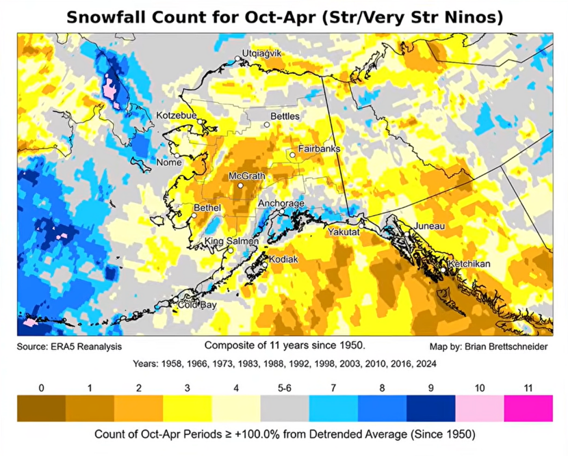
Brettschneider analyzed how 11 major El Niño events since 1950 affected snowfall between October and April across the state. He made a map showing that those El Niño events led to below average snow for most of Alaska, besides a couple of places in Southcentral.
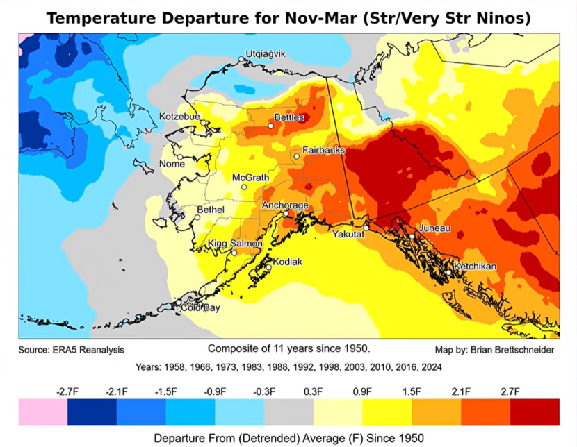
Another map shows above average winter temperatures throughout Alaska during major El Niño events, except for the North Slope.
In an interview with KTOO, Brettschneider said snow sports enthusiasts might be disappointed in Southeast. But Juneau residents who spent last winter shoveling record-breaking snow from roofs could be relieved.
“For Southeast Alaska, it’s a very, very strong signal historically for warmer than normal temperatures and less snow than normal,” he said.
But he said the past isn’t a blueprint for the future, and all options are still on the table.
In Southeast Alaska, 3 of the 11 major El Niño winters were snowy. Those were the winters of 1965-66, 1987-88 and 1991-92.
An El Niño becomes “super” when sea surface temperatures in the tropics remain more than 2 degrees Celsius warmer than average for a few months. Brettscheider said that’s extremely likely this fall and winter.
“We are easily going to hit a three-month value of plus two, and that’s the criteria for a super — I’m sorry — a strong, Godzilla El Niño,” Brettschneider said in the video.
Scientists predict topical ocean temperatures could hold at 2.5 degrees Celsius above normal or higher, which would make this El Niño the strongest in recorded history.
According to a study published in the journal Science in August, El Niño-driven temperature swings have grown 36% stronger over the past four decades. The authors suggest it’s a result of climate change.
As the ocean warms, it releases heat into the air. That’s particularly noticeable in the winter — especially for Southeast Alaska, where usual winter temperatures hover around freezing. Just a slight rise in temperature can turn snow to rain.
But Brettschneider said he doesn’t have a prediction on whether precipitation will be higher or lower than normal in Southeast this winter.

