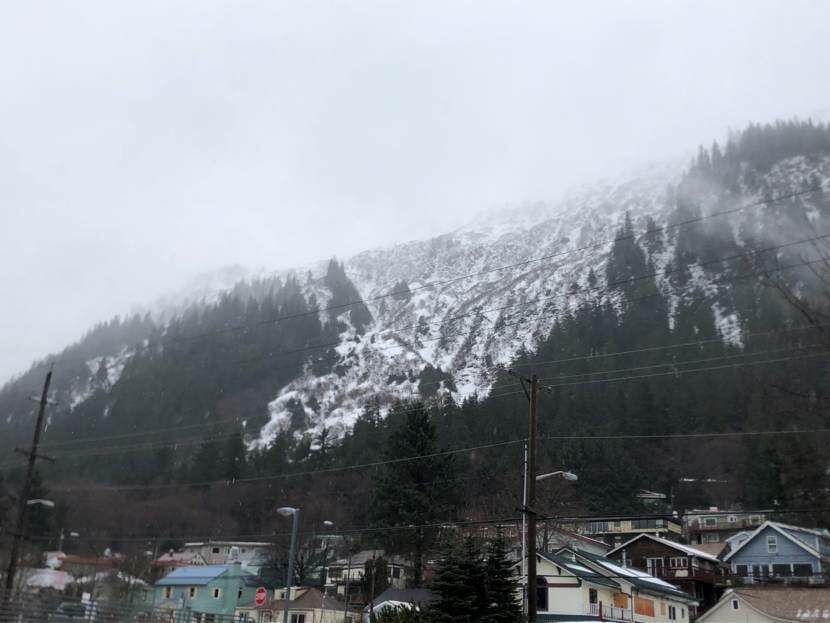
As heavy snowfall hits Southeast Alaska this weekend, Juneau’s urban avalanche forecast will be up and running for the first time this season.
Tom Mattice is Juneau’s emergency programs manager. He says he’ll keep an eye on the mountains as the avalanche cycle begins this weekend.
“In the backcountry in the high mountains, there’s gonna be pretty big avalanches,” he said. “I don’t necessarily see it coming into the urban environment just yet. But things are gonna change a tremendous amount over the next few days.”
Mattice says the recent cold snap, combined with this weekend’s forecast, will create ideal conditions for avalanches in the high mountains.
“We’ll see several feet of snow over several days. And during that time, it’s warming up, and towards the end of that it’ll even see some rain at sea level. So all of that is trending in a bad direction,” he said.
The incoming snow may not bond well with the existing snowpack, which would increase avalanche risk.
“We’re going to see an upside down snowpack where we’re going to put heavier, denser snow on lighter, looser snow,” he said.
Juneau faces greater urban avalanche risk than any U.S. city, with avalanche paths threatening multiple neighborhoods and roads. Mattice updates the urban avalanche advisory at 8 a.m. daily throughout the season, with ratings on a danger scale that runs from 1 to 5. Updates will be live starting this Saturday.
Forecasting avalanches can be complex. Mattice monitors snow accumulation over the season and keeps close track of daily weather forecasts. He also measures the snowpack with frequent field trips to look for weak snow layers.
Many of Mattice’s considerations are centered around what makes snow layers bond together.
“It starts with what’s on the ground in the mountains,” Mattice said.
This winter, there haven’t been many days of heavy snow in Juneau. That means rough terrain with trees, rocks, bushes and shrubs is still exposed, which helps to anchor snow. That will start to change this weekend as snow accumulates.
“As we start seeing more and more snow in the terrain, those things start getting buried, and the more they get buried, and the wider areas you’d have, that are smooth and flat, the bigger your starting zones become,” Mattice said.
Over the course of the winter, the risk depends less on the amount of snow and more on the consistency of the weather. Even winters with tremendous amounts of snow can be relatively safe if that snow falls steadily throughout the season. That tends to build a stable snowpack in the mountains. But weak layers form when snow storms come between long breaks of sun, wind or rain. That makes the snowpack unstable.
The city only forecasts for urban avalanche risk, but Mattice said that can be a good proxy for people venturing out into the backcountry, or even on the Flume Trail and Upper Perseverance Trail near downtown. When urban avalanche risk is high, backcountry risk will be even more extreme.
Mattice will update his forecasts daily. He encourages people to stay informed as conditions change throughout the winter.
“People have to make their own educated decisions,” he said. “But you go through periods of time that are quite safe. And then you know overnight, you can have a situation that changes and things get very dangerous.”
Mattice encourages anyone who does go out into the backcountry to submit avalanche observations to the Alaska Coastal Avalanche Center.
