Juneau is in for a wet week. An air mass originating in the subtropics is bringing warm air and a lot of rain to Southeast Alaska.
National Weather Service Forecaster Wes Adkins said about 3.3 inches of rain fell on downtown Juneau between Friday morning and Monday morning.
“As the air is transported northward it will cool and that actually helps to saturate the air mass and produce so much rain, particularly when it collides with our complex terrain here over Southeast Alaska,” Adkins said.
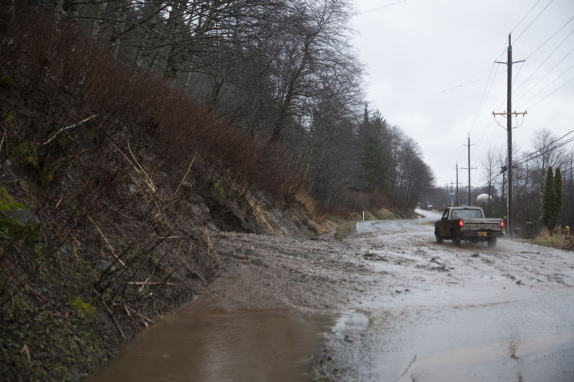
Heavy rains appear to have caused a mudslide Monday afternoon along a portion of Thane Road.
The road was briefly reduced to one lane after the bluff collapsed along the road, leaving thick mud in the northbound lane. About a quarter-mile of the road was flooded with fast-moving water. The Alaska Department of Transportation cleared it.
Many communities in Southeast Alaska saw temperatures in the 50s. Metlakatla recorded a maximum temperature of 63 degrees.
“Most residents of Southeast can attest that our winters are rarely, completely consistent,” Adkins said. “We generally have seesaw patterns. We kind of live right in the middle of the storm track. And by nature, that means that we’ll have some warm spells ahead of systems and some cooler spells behind it.”
Adkins said rain should continue through the night, though not as heavy, and diminishing over the Tuesday afternoon. A strong front is moving into Southeast Alaska on Wednesday night, bringing more heavy rain.
The National Weather Service issued a flood advisory for Jordan and Montana creeks. Adkins said those creeks are at bank full and are being monitored.
Eaglecrest Ski Area marketing director Jeffra Clough said warm temperatures and rain over the last week have affected the snowpack.
“The snow is melting and the ground is now longer frozen underneath it, so unfortunately the snow melts from below and above, as well,” Clough said.
Ponds of water and icy spots are beginning to form. Clough said they need the temperatures to drop to make more snow.
“We’re keeping our fingers crossed and doing our snow dances.”
As of Monday, Clough said the snow is beginning to stick again. And more snow is in the forecast starting Thursday night.
— Alaska’s Energy Desk reporter Rashah McChesney contributed to this report.
