After years of gravel extraction in the mid-20th century, Sitka’s Indian River has changed. It’s become straighter, and its banks are deep.
Hydrologists surveyed the river over 20 years ago and discovered problems that could affect salmon spawning.
This fall, students and area scientists repeated the study to see just what, if anything, has changed in the Indian River watershed.
It’s 1 p.m. on a school day, and a group of wetsuit-clad Mt. Edgecumbe High School students are splashing around in Indian River.
But they’re doing so with a purpose.
They’re collecting data in collaboration with the Indian River Working Group as a part of their field research class at MEHS.
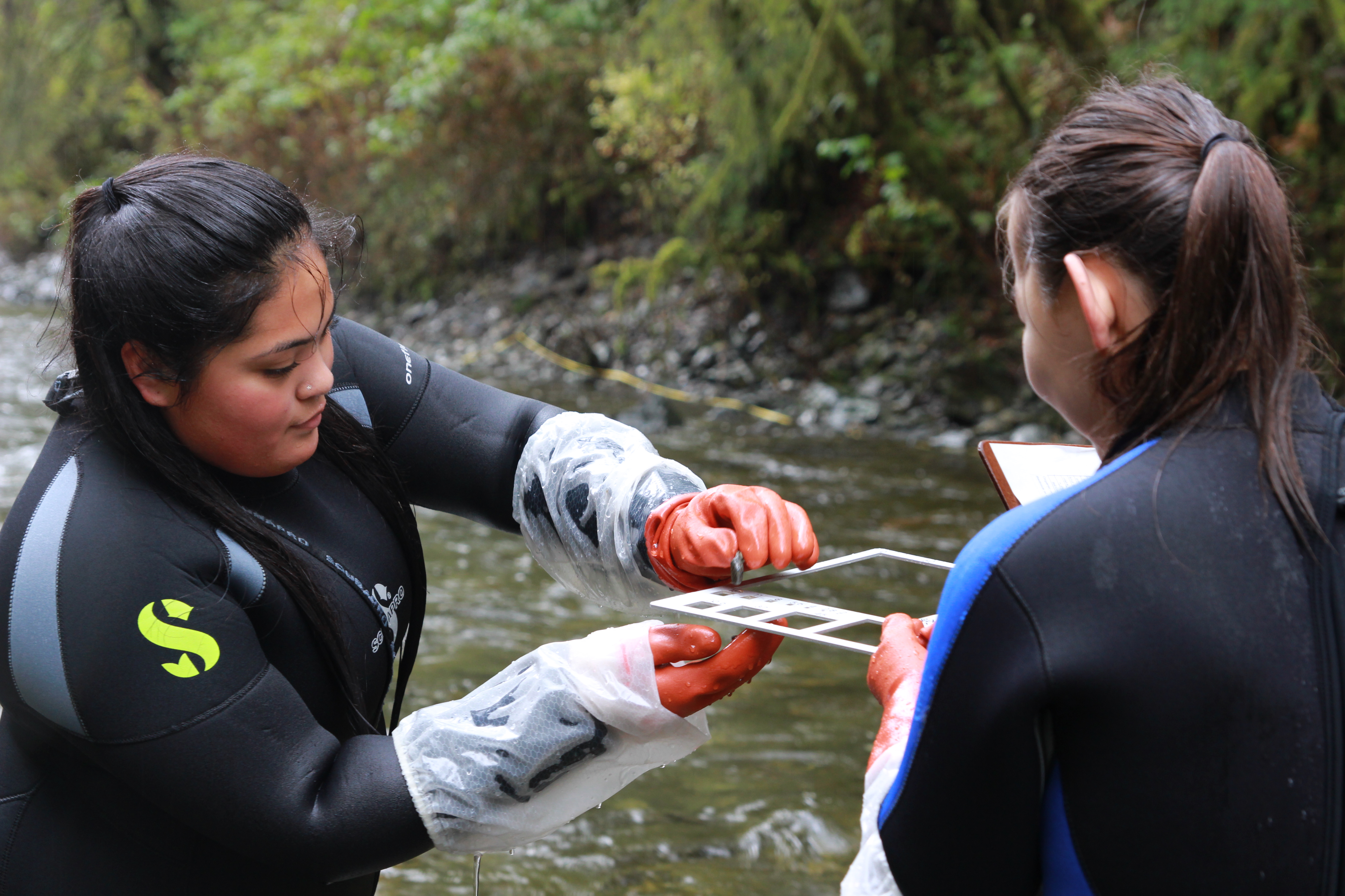
“We’re collecting rock samples to check the sizes so we can find out whether or not the water is suitable- what type of life it holds,” Harlan Standish said. “Using this handy-dandy rock measuring tool.”
The “handy-dandy” tool is a thin metal frame with square holes of different sizes.
Working in groups of two, students grab rocks from the riverbed, and measure the diameter of each rock they pick up.
It’s not easy, the rocks are slick.
“To keep from getting a biased sample, take a step, place your foot — whoa, almost fell — and then pick up the rock right in front of your big toe. Same spot every time,” Standish said.
Students are repeating a study done in 1995 by Steve Paustian and Tom Hardy for the U.S. Forest Service.
The data MEHS students collect will have serious implications about the river’s current health.
Sitka Tribe of Alaska hydrologist Jenn Hamblen said you can trace the problems with the Indian River watershed back to a military project beginning around World War II.
“Among other things they needed gravel to expand their operations,” Hamblen said. “They actually had to mine gravel from the bed of the river where it meets the estuary.”
Now, there’s a big hole at the river’s mouth that the river is constantly compensating for, trying to fill in with sediment by cutting sharply into its banks.
Hamblen said the river is deeply entrenched in some sections, with the banks often 10 or more feet above the river bottom.
“Rivers like to move. They like to change their pattern. It’s not really possible for the Indian River in it’s lower watershed to move or to connect with its floodplain. If it could get up there more frequently, there would be more exchange of nutrients.”
And the river moves so quickly, it’s washing the smaller gravel away. That’s a big problem for salmon.
“There’s a lot of pretty big rocks in the bed. It’s mostly cobbles and bigger — 6 inches in diameter,” Hamblen said. “If you think about the size of your average spawning salmon, and how much they weigh compared to these rocks, it’s pretty hard for them to find good places to spawn in this kind of setting.”
It had been over 20 years since Paustian’s study when MEHS teacher Chohla Moll took her field research class out to the river with Hamblen and members of the Forest Service.
“We were standing out here, and they were talking to us about all the different impacts of this river,” Moll said. “One of my high school students was standing there. They said ‘Well, what are you gonna do about it?’ It kind of got all the adults to look around and say, well, yeah. Let’s do something about it!”
They’ve measured off a section of the river — the same that Paustian used in 1995 to collect his data.
Each team is supposed to collect and record the sizes of 100 rocks, but Kori Itta-Thomas and Katelynn Johns are literally diving right in.
“Counted at least 120. We’re going further. It’s really fun, we’re getting further into the water.” For Itta Thomas, it’s a window into a potential career. “I’m thinking about going into biology, so this hands-on experience has been really fun, getting to encounter this type of work. I feel like I could be doing something like this in the near future.”
Back in the classroom, students start to break down the data they’ve collected.
“We’ve got all the calculations done. Now we just need to make the graphs so we can visually see what that 50th rock looks like,” Moll said as students start to peel through their papers.
Once they’ve recorded everything, they’re making graphs charting the rock sizes and comparing their data to that from 1995.
“It was similar, it actually may have been a little less,” Standish said. “More smaller rocks. This is also just from our data. We kind of have to compare it with everyone else’s.”
And they won’t just turn their assignments in at the end of class.
They’ll present their findings, alongside scientists, at the next Indian River Working Group meeting.
Although it’s a class, it’s the real thing.
“This is one way we do science, and that’s what they’re getting to experience, all the messy crazy ways we do science,” Moll said.
Whether pebbles or cobbles, these students are learning that science rocks.
