Arctic sea ice is rapidly shrinking, but National Geographic is only on its ninth edition of its Atlas of the World since 1963.
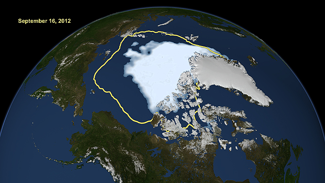
In the upcoming 10th edition of the atlas, Arctic ice is depicted as it was in 2012, based on NASA satellite data.
“The ice cover during the summer in 2012—this is the record-low ice cover—is less than 50 percent of what it was in the 1980s,” says Josefino Comiso, lead researcher of the NASA satellite study. He says it is important to redraw the map, since the Arctic is changing so rapidly.
The map is controversial. It only shows multiyear ice, which doesn’t melt during warmer seasons. Cartographers didn’t want to include new ice because it might be too confusing.
New ice is still important to the Arctic landscape, providing shelter for animals and reflecting solar energy. It also poses risks to Arctic Ocean-going vessels.
“An ocean that’s covered with first-year ice—which is going to be a bit thinner—it’s still hazardous,” says Andy Mahoney, Assistant Research Professor at the Geophysical Institute at the University of Alaska Fairbanks. “You still can’t take a non-ice-reinforced vessel into those waters.”
Mahoney says showing an average of ice levels taken over a few years would make the map more representative than the record-low ice year.
“It’s also a very political issue. I think it behooves everyone to do the best job they can to make sure they’re using relevant and representative data when drawing a line on a map which can have profound implications sometimes,” he says.
New ice is becoming increasingly important to people in the Arctic, says UAF geophysics professor Hajo Eicken.
“Nowadays, if you go up to Barrow towards the end of summer, the closest ice may be several hundred miles away. You have open ocean out there, and for people in Barrow these days, the first-year ice is just as important as the multiyear ice,” he says.
But Arctic ice is changing so rapidly, the cherry-picking argument may be moot in a few years, Eicken says.
“Ten years from now we might say ‘Whoa, why did they pick 2012 when there was so much ice left? Why aren’t they updating this so much more quickly?’” Eicken says.
The new atlas comes out Sept. 30.
