The City and Borough of Juneau is asking its assembly to adopt updated hazard maps. A new scientific report puts about half of the structures downtown at moderate to severe risk of landslide or avalanche. But some residents say they aren’t ready for the upgrade.
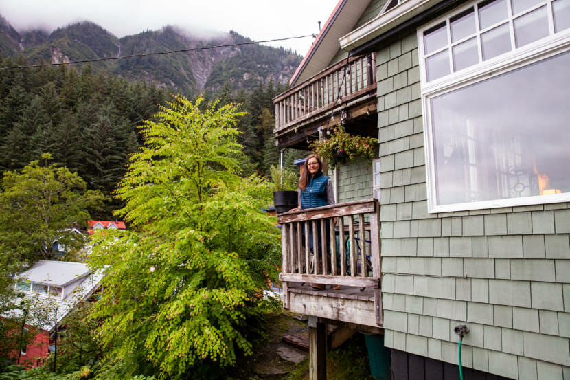
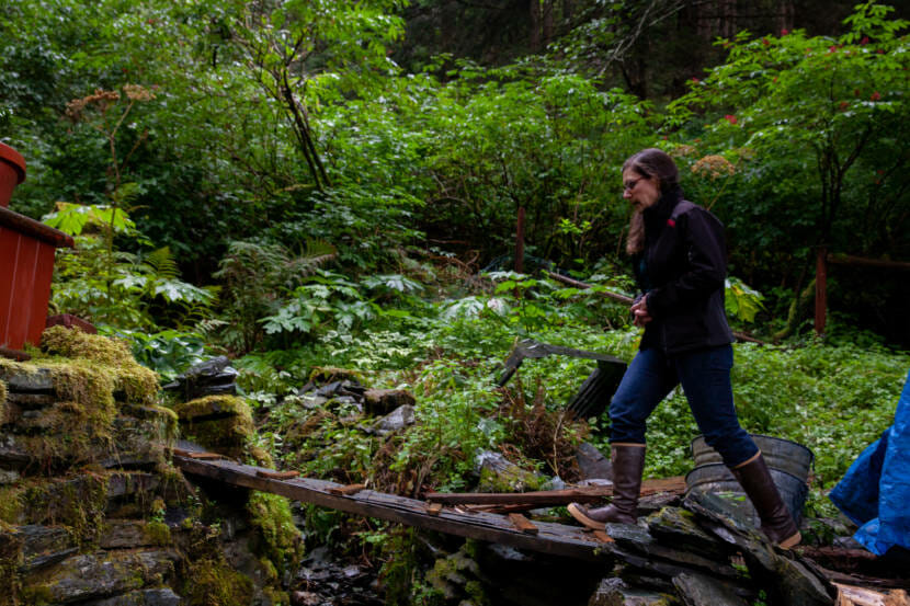
The Starr Hill neighborhood is nestled into the side of Mount Roberts above downtown Juneau. Sally Schlichting is pushing through some brush on the steep hillside behind her home of 20 years.
“This is a rather unique situation,” she said, gesturing at a stone-lined gully.
When it rains, water flows down the hillside through the gully. She says debris has come down, too, in storms. So when she looks at the new hazard maps the city is proposing, she’s certain this is where the contractors think there’s a severe risk of landslides.
“We had previously been in a moderate landslide zone. And these maps now had us depicted in a severe landslide zone, which was kind of a shock and a major change for us,” Schlichting said.
It was a major change for about a dozen of her immediate neighbors, too. She says the new maps — and all geotechnical information that comes with them— are a lot to digest.
“We just got this information, maybe a month or so ago, and we all need to kind of catch up,” she said. “We need time to catch up with the city in all of this. When it’s your home, and the place where you raised your kids…”
The buzz of neighbor’s saw cuts Schlichting off, but her point is this — it’s emotional, too. She’s lived here for decades, and she says nothing really bad has happened yet.
“I felt like, you know, I felt blindsided by it, but perhaps not too surprised. After I read the report, I felt like the science seems pretty sound,” Schlichting said.
So she’s one of a lot of downtown residents questioning whether or not these new maps do them too much financial harm to be worth their intended public safety value.
And this is the tricky piece — hazard maps ideally come before development. Now the assembly has to decide whether it’s right to adopt the maps or wait until it’s clear what the effects will be on the significant number of people whose downtown property would then be in a hazard zone.
“From my perspective, it wasn’t wise to make those changes without a full understanding of the impacts the changes might have,” said Mike LeVine, chair of the city’s planning commission.
While he can’t speak for the commission as a whole, he said it’s complicated to adopt the maps because that comes with changes that could affect people like Sally Schlichting.
The commission was divided on the issue, but the majority voted to tell the assembly to wait to adopt new safety maps until residents have a better sense of what it means for their homes. Others said the science speaks for itself and voted to recommend the assembly adopt the maps.
“It is not clear, at least to me, whether these changes could have effects on property values for individual owners,” LeVine said. “And could these changes have effects on homeowners’ ability to sell their property or to get financing for purchasing a property? I don’t have the answer to these questions.”
The city doesn’t have those answers either.
“They’re tough questions. They’re very important questions, and we obviously don’t know the answer to them. They’re market questions,” said Teri Camery, Juneau’s senior planner. She’s in charge of the project to evaluate landslide and avalanche risk downtown. She says from a public safety perspective, the city needs new maps now. The ones they have are from the ’70s.
“We know they are outdated. They’re inaccurate. And we’ve had a lot of really serious storm events in Southeast Alaska the past few years. We’ve had deaths from landslides in both Sitka and Haines. And it’s just really critical to get updated hazard information to protect public safety and public property,” Camery said.
Camery says that even though these areas are already developed, there are still a lot of important decisions to be made about where development can increase, and where it may need to be cut back.
Money is also the reason why the department asked the city to adopt the maps now and consider regulations and the market implications later. There’s federal money available for both the maps and the regulations that will affect homeowners, and they come at separate times. Initially the planning department thought it needed the maps to be accepted before it got money to talk about regulations. Camery says that might not be the case any longer.
But back on Starr Hill, Sally Schlichting is worried her home could lose market value and even become uninsurable. Ultimately, she’s not sure if she wants this map upgrade at all.
“Would I like to see them get passed? I think I, I struggle with that,” she said.
She says she wants people to be safe. And for her, that makes the discussion worthwhile.
The maps will be considered in Committee of the Whole meeting on Sept. 20 before they are scheduled for a first reading before the assembly.
Either way, the maps are out there. Regardless of whether the assembly adopts them, they’ll be available on the city’s website.
Correction: the maps will be considered at only one meeting on Monday, September 20th.