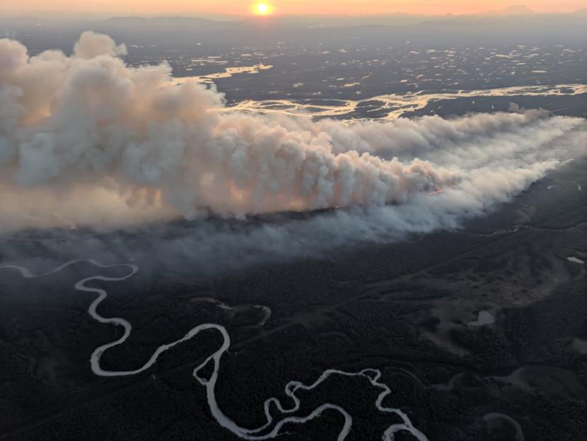
Usually by August, peak fire season has passed. But fire and climate experts say conditions in Southcentral Alaska were nearly perfect for fire this weekend, from the sky to the dry forest floor.
“Every red flag condition you can think of: dry, windy, sunny, low relative humidity, long-term drought. It all added up,” said University of Alaska Fairbanks climate scientist Brian Brettschneider. “It all came together on Sunday.”
Consider the duff — that’s the layer with moss, fallen spruce needles and decomposing leaves. Robert Ziel is a fire analyst who works for the Alaska Fire Science Consortium. He said duff in the vicinity of multiple Southcentral fires is registering at the “extreme” end of something called the “Duff Moisture Code.”
“Yesterday’s Duff Moisture Code, instead of being 25-to-30, was 75-to-80, so almost triple,” Ziel said.
In other words, very dry. But far more obvious signs also point to an abnormal August.
Southcentral has had the warmest summer on record “by very wide margins,” Brettschneider said. He has seen a lot of records broken this summer. After so many extremes, a climatologist has to range far afield to illustrate how weird the weather has been. Like the fact that, as of Monday, Anchorage has had no measurable rain since July.
“Death Valley, California, has had 0.2 inches of rain this August,” Brettschneider said. “So they’re out-raining us in Death Valley so far this month.”
While warm, dry air has added to the fire danger south of the Brooks Range, it’s soggy in the Interior.
“August is barely more than half over. It’s already a top-10 wettest month” for Fairbanks, Brettschneider said. “Any month, in any year.”
It’s all due to something called a heat dome. A high-pressure mass has been sitting over Southcentral nearly all summer. Storms can’t get in, and Fairbanks is outside the dome.
Under the dome, Brettschneider said smoke from wildfires has no place to go.
“As of today, we just passed over 200 hours in Anchorage of smoky conditions that reduce visibility at the airport, and that far exceeds any other year on record,” he said.
Anchorage air quality reached unhealthy levels Monday, and the city issued a health advisory.
You can also blame Sunday’s fierce wind on the dome, because low-pressure areas are diverting around it. Meanwhile, the dome has shifted: It had been centered on Anchorage, but Brettschneider said a few days ago it began scooting west, leaving Anchorage closer to the edge. Dry, northerly winds snuck in and whipped the city, shattering another record.
“The wind gusts that we had at Anchorage International Airport on Sunday were the strongest winds ever measured at the airport in any summer month,” Brettschneider said.
Climatologists around the country look to the Arctic as the region on the forefront of climate change, he said, and Alaska’s weird summer has them concerned.
“So (there’s) a lot of discussion in the climate community about tipping points and, ‘Is this the new normal, and how much of this is a trend?’ … and what it all means,” Brettschneider said.
The high temperatures for Anchorage are predicted to be in the 60s all week, and there’s still no rain in sight.
