The chairman of the Alaska Redistricting Board says state residents need to have a conversation about the growing number of people who live in each legislative district.
In 2010, when the current Redistricting Board started working on new political boundaries, Alaska’s population was about 714,000. Divided by 40 House districts, that’s nearly 18,000 people for each member of the Alaska House of Representatives and about 35,500 for each member of the Senate.
Board Chair John Torgerson says the state’s population is expected to grow to at least 820,000 within the decade – even more if some industry or project, such as a major natural gas pipeline, brings people to the state.
“The districts are going to go from over 17,000 to over 20,000 in 2020,” said Torgerson.
His estimate is backed by the Alaska Department of Labor, which projects the state population could be nearly a million people by 2030.
In 2010, voters rejected a proposed constitutional amendment that would have added six seats to the Alaska Legislature – four new House members and two new Senators – reducing the size of legislative districts.
“The question is certainly not mine to answer as to whether or not we should add more folks to the legislature, look at a unicameral legislature, make everybody Senators,” Torgerson said. “So you’d have 60 people, you would take that mass, divide it by 60, whatever it is. But we need to have that conversation.”

Last month, a Fairbanks Superior Court judge approved the Redistricting Board’s final plan, which was developed over three years and numerous court challenges. The only thing left to determine is whether the board or the plaintiffs in the case are the prevailing party for purposes of winning legal fees.
“The good news is it’s done,” said Torgerson.
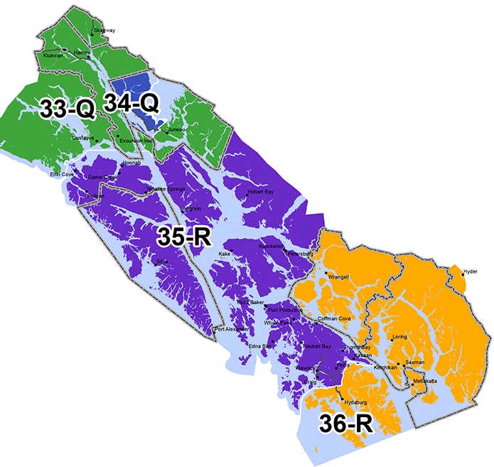
Petersburg challenged the temporary redistricting plan used in 2012, which put the community with downtown Juneau and Douglas Island. Mayor Mark Jensen says the borough is satisfied with the final map, which pairs it with Sitka, Prince of Wales Island, and other smaller Southeast communities. He says those are a better socio-economic fit than the Capital City.
“We’re a little different, I think. We’re totally a fishing community with some government here too, state and federal,” said Jensen. “But a little bit different than Juneau being mainly a government type town.”
The final map, which takes effect for this year’s elections, puts downtown Juneau and Douglas in a district with Haines, Skagway, Tenakee Springs, and Gustavus.
Torgerson blamed the court system for delaying the plan by taking too long to issue opinions. He said the next redistricting process in 2020 should go more smoothly, after the U.S. Supreme Court last year struck down a section of the federal Voting Rights Act that determined whether or not Alaska needed to get preclearance for Native voting districts.
“I personally think it will be substantially easier, just using the Alaska Constitution as the only guideline, and not having a lot of overlapping federal laws there,” Torgerson said.
He spoke Thursday to a lunch gathering of lawmakers and business leaders during the Alaska State Chamber of Commerce’s annual legislative fly-in. The event was co-sponsored by the Juneau Chamber of Commerce.
