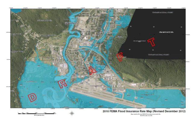
The Federal Emergency Management Agency has given the City and Borough of Juneau an August 19th deadline to adopt new flood zone maps.
The city and FEMA have been involved in a nearly two-year dispute over the accuracy of the maps, which are required for participation in the National Flood Insurance Program. Last year, FEMA removed several properties in the Mendenhall Valley from flood plains after the city hired a consultant to analyze the federal agency’s work and provide additional data and information.
CBJ Community Development Director Hal Hart told the Juneau Assembly on Monday that FEMA officials acknowledge continued errors in the maps, but are not accepting additional changes at this time.
“They’re saying ‘Save those changes that you come up with, and you can use the map amendment process.'” said Hart. “But they need to have these adopted, and the federal process is a longer process than we’re attuned or used to, I guess.”
It’s not clear how long it would take to amend the maps. Hart says about 160 properties will be placed in newly created flood zones under the FEMA proposal, while about 180 will be removed.
The city could choose not to adopt the maps. But Hart says that would increase insurance rates for about 700 property owners, because the federally backed National Flood Insurance Program is cheaper than private insurance.
Assembly members were not happy about the idea of adopting maps that may be inaccurate.
“It doesn’t sound like a very good deal for our citizens at all,” said Mayor Merrill Sanford.
Juneau’s FEMA flood plain maps have not been updated in nearly 20 years. The Community Development Department will host a series of public meetings this week and next to discuss the changes.
Draft Flood Maps Public Meeting Schedule:
Downtown Juneau
Tuesday April 2, 2013
Juneau-Douglas HS library, 6-8 p.m.
Douglas
Wednesday April 3, 2013
Douglas Library, 6-8 p.m.
Mendenhall Valley
Wednesday April 10, 2013
Riverbend Elementary library, 6-8 p.m.
Auke Bay
Thursday April 11, 2013
UAS lecture hall, lower level Egan Library, 6-8 p.m.
2013 Draft Flood Maps (PDFs):
North of Auke Bay
Auke Bay
Mendenhall Valley 1
Mendenhall Valley 2 (Revised December 2012)
Lemon Creek
Downtown Juneau
Douglas
North Douglas & Salmon Creek
North Douglas
(Note: Areas in blue on these maps represent areas that would be flooded during a 100 year flood event. These areas also are flood zones where flood insurance is required to be purchased. Maps courtesy City and Borough of Juneau).
